About Singapore MRT Map Route
Get the fastest route in 2 clicks. Updated Thomson-East Coast Line (TE1 Woodlands North to Orchard) to the subway system. Updated Thomson-East Coast Line (TE1 Woodlands North to Orchard) to the subway system Singapore's MR
Get the fastest route in 2 clicks. Updated Thomson-East Coast Line (TE1 Woodlands North to Orchard) to the subway system.
Updated Thomson-East Coast Line (TE1 Woodlands North to Orchard) to the subway system
Singapore's MRT system is extending. By 2030, the MRT system will be more complex than you could image. It's good for all residents on our lovely island. But also will be a problem because we don't know how to travel the fastest when transfering stations.
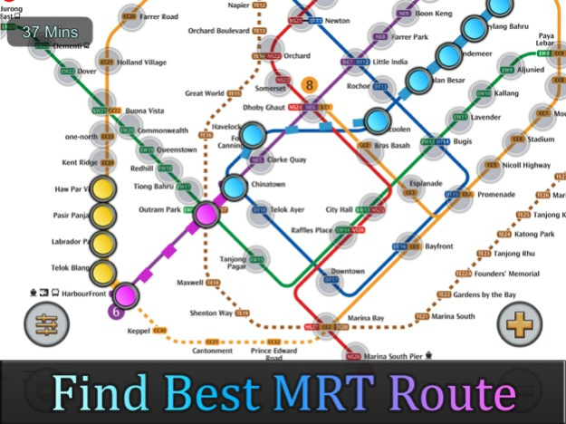
Singapore MRT Map Route is designed to allows user to get the best route within a second. It will help you save a lot of time over years.
- View lastest Singapore MRT map
- Display the best route between two stations
- Automatically calculate estimated travel time
- Require no internet connection.
Updated to latest MRT system:
Downtown Line(Blue)
Bukit Panjang, Cashew, Hillview, Beauty World, King Albert Park, Sixth Avenue, Tan Kah Kee, Botanic Gardens, Stevens, Newton, Little India, Rochor, Bugis, Promenade, Bayfront, Downtown, Telok Ayer, Chinatown
Circle Line(Yellow)
Dhoby Ghaut, Bras Basah, Esplanade, Promenade, Nicoll Highway[C], Stadium, Mountbatten, Dakota, Paya Lebar, MacPherson, Tai Seng, Bartley, Serangoon, Lorong Chuan, Bishan, Marymount, Caldecott, Botanic Gardens, Farrer Road, Holland Village. Buona Vista, one-north, Kent Ridge, Haw Par Villa, Pasir Panjang, Labrador Park, Telok Blangah, HarbourFront
East West Line (Green)
Pasir Ris ,Tampines , Simei , Tanah Merah , Bedok , Kembangan , Eunos , Paya Lebar , Aljunied , Kallang , Lavender , Bugis , City Hall , Raffles Place , Tanjong Pagar , Outram Park , Tiong Bahru , Redhill , Queenstown , Commonwealth , Buona Vista , Dover ,Clementi , Jurong East , Chinese Garden , Lakeside , Boon Lay , Pioneer , Joo Koon, Expo,
Changi Airport
North South Line (Red)
Jurong East, Bukit Batok, Bukit Gombak, Choa Chu Kang, Yew Tee, Kranji, Marsiling, Woodlands, Admiralty, Sembawang, Canberra, Yishun, Khatib, Yio Chu Kang, Ang Mo Kio, Bishan, Braddell, Toa Payoh, Novena, Newton, Orchard, Somerset, Dhoby Ghaut, City Hall, Raffles Place, Marina Bay, Marina South Pier
North East Line (Purple)
HarbourFront, Outram Park, Chinatown, Clarke Quay, Dhoby Ghaut, Little India, Farrer Park, Boon Keng, Potong Pasir, Woodleigh, Serangoon, Kovan, Hougang, Buangkok, Sengkang, Punggol
Jul 12, 2023
Version 2.4.5
Updated Thomson-East Coast Line (TE1 Woodlands North to Orchard) to the subway system
Optimized calculation speed to improve the overall performance of the application.
Fixed known issues and bugs to enhance the stability and reliability of the application.
Previous Versions
Here you can find the changelog of Singapore MRT Map Route since it was posted on our website on 2016-09-24 16:19:04.
The latest version is 2.4.5 and it was updated on 2024-04-22 09:10:59. See below the changes in each version.
Singapore MRT Map Route version 2.4.5
Updated At: 2023-07-12
Changes: Jul 12, 2023
Version 2.4.5
Updated Thomson-East Coast Line (TE1 Woodlands North to Orchard) to the subway system
Optimized calculation speed to improve the overall performance of the application.
Fixed known issues and bugs to enhance the stability and reliability of the application.
Singapore MRT Map Route version 2.4
Updated At: 2019-11-13
Changes: Nov 13, 2019
Version 2.4
Added New station for North East line: Canberra
Updated to latest MRT map. Includes future lines.
Added What’s New panel to display upgrade logs.
Optimizing Pan, Scale gestures movements, preventing sudden moves.
Added rewarded Mcoin function.
(Kindly show appreciation and support developer for hardworking)
Singapore MRT Map Route version 1.7.0
Updated At: 2012-06-28